Aug 6, 2015

Feb 5, 2015
Google Earth Pro Seharga Rp 5 Juta Kini Digratiskan

Dilansir KompasTekno, Minggu (1/2/2015), dari Gizmodo, hingga saat ini Google belum memberi tahu secara resmi alasan aplikasi Google Earth Pro digratiskan.
Seperti diketahui, Google Earth memungkinkan penggunanya melihat gambaran bumi serupa aslinya melalui layar perangkat elektronik.
Lingkungan sekitar rumah atau tempat-tempat yang ingin diamati, dapat dilihat melalui aplikasi ini.
Google Earth Pro adalah versi lebih canggih dari Google Earth. Versi lanjutan ini mampu mengukur bangunan 3D, memberikan tampilan dengan gambar HD 4800 piksel (Google Earth biasa hanya 1000 piksel), mencari letak geografis secara otomatis, dan merekam film HD pada penerbangan virtual di seluruh dunia.
Semua kecanggihan tersebut kini tersedia secara gratis. Pengguna hanya perlu mengunjungi tautan ini untuk mendapatkan aplikasi Google Earth Pro.
Aug 26, 2013
Laporan "Gangguan Jalan" Tersedia di Google Maps
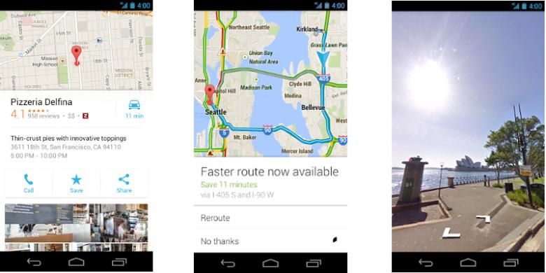
Seperti dilaporkan oleh The Verge, Google pada Selasa (20/8/2013) mengumumkan penerapan fitur pelaporan gangguan jalan secara langsung di aplikasi mobile Google Maps, mirip dengan yang terdapat pada Waze.
Gangguan jalan dimaksud bisa bermacam-macam, seperti banjir, penutupan jalan, atau kecelakaan. Tujuan pelaporannya adalah memberi tahu pengguna Maps lainnya agar bisa menghindari daerah yang bermasalah. Fitur ini adalah salah satu ciri khas aplikasi peta sosial bikinan Waze.
Di Google Maps, yang menjadi pelapor kejadian bukanlah pengguna software itu sendiri, melainkan para pengguna Waze.
Jadi, setiap kali anggota Waze melaporkan suatu kejadian, pemakai Google Maps juga bisa melihat laporan tersebut secara realtime. Namun, para pengguna Google Maps tak bisa memberi laporan, tetapi hanya melihat.
Fitur ini akan mulai tersedia untuk pengguna Google Maps di Argentina, Brasil, Cile, Kolombia, Ekuador, Perancis, Jerman, Meksiko, Panama, Peru, Swiss, Inggris, dan Amerika Serikat. Wilayah-wilayah lain akan menyusul setelahnya.
Mar 11, 2013
Google Maps Tampilkan Informasi Lalu Lintas Bandung
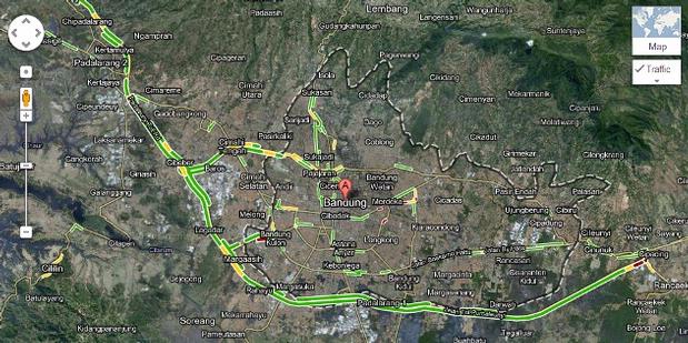
Ada tiga warna jalur yang merepresentasikan kondisi lalu lintas. Jalur yang berwarna merah adalah kondisi dalam keadaan kemacetan luar biasa, kuning untuk padat merayap, dan hijau untuk lalu lintas lancar.
"Kami harap ini akan membuat Google Maps lebih bermanfaat bagi pengguna internet Indonesia, terutama bagi Anda yang selalu terjebak macet di Bandung pada akhir pekan," tulis Google Indonesia dalam siaran pers yang diterima KompasTekno, Selasa (6/3/2013)
Data lalu lintas yang ditampilkan pada Google Maps berasal dari berbagai sumber, termasuk instansi perhubungan, penyedia data pribadi, dan pengguna Google Maps yang mengakses dari perangkat mobile yang memberi kontribusi informasi secara anonim melalui fitur crowdsourcing lalu lintas.
Data lalu lintas itu bisa di-refresh setiap beberapa menit untuk mengetahui kondisi terbaru. Sehingga, pengguna dapat dengan mudah menentukan jalur alternatif dalam mengantisipasi kemacetan yang mereka hadapi.
Nov 17, 2012
Here, Peta Digital "Independen" Buatan Nokia
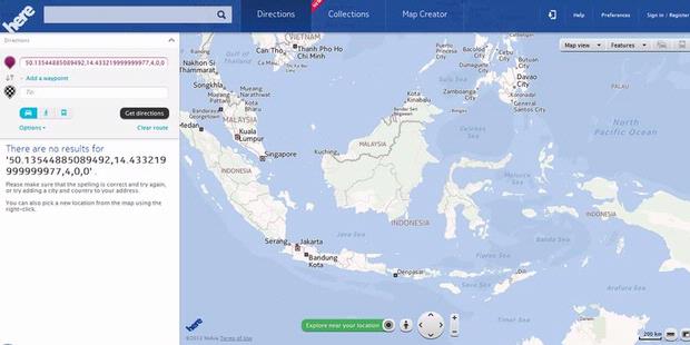
Meski dibuat oleh Nokia, bukan berarti Here eksklusif hanya untuk ponsel Nokia. Aplikasi Here akan dirancang untuk sistem operasi mobile iOS, Android, Windows Phone, hingga Firefox OS pada 2013 mendatang. Here juga bisa diakses dari segala macam browser di komputer bersistem operasi Windows dan Mac.
"Banyak orang membutuhkan peta yang baik, dan dengan Here kita bisa menyatukan lokasi yang Nokia tawarkan untuk cara lebih baik dalam mengeksplorasi, menemukan, dan berbagi dunia mereka," kata Presiden dan CEO Nokia Stephen Elop dalam siaran persnya.
Nokia berjanji, Here untuk iOS akan dirilis beberapa pekan mendatang, yang mencakup kemampuan akses offline, panduan navigasi suara, dan arah transportasi publik.
Nokia juga menjalin kerja sama dengan Mozilla untuk membuat Here di sistem operasi mobile Firefox OS pada tahun depan.
Untuk Android, Nokia akan merilis software development kit (SDK) Here untuk para produsen ponsel dan tablet Android di tahun 2013 nanti. Tujuannya, memungkinkan para produsen Android menciptakan aplikasi peta digital yang menggunakan konten Nokia.
Saat ini, Here bisa diakses melalui situs web di alamat www.here.com. Layanan tersebut menggunakan teknologi komputasi awan, yang bisa disinkronisasikan dengan akun Nokia pengguna. Dengan ini, pengguna dapat mengakses data peta pribadi dari perangkat apa pun.
Here juga memanfaatkan penggunaan data yang diserahkan secara kolaboratif oleh penggunanya melalui menu Map Creator. Menu ini mempersilakan pengguna untuk menambah nama jalan atau tempat di sekitarnya, arus lalu lintas, dan sebagainya.
Nokia mengklaim, Here menawarkan proses rendering yang lebih cepat, tetapi penggunaan bandwidth internetnya rendah.
Dari pengalaman KompasTekno mengakses Here dan Nokia Maps dari komputer, kinerja Here memang lebih cepat. Untuk melihat peta dalam tampilan 3D di Here, pengguna tak perlu lagi meng-install plug-in. Meskipun tampilan antarmuka Here dan Nokia Maps di situs web nyaris sama, Here memiliki fitur yang lebih lengkap.
Untuk memperkuat layanan peta digital, Nokia berencana mengakuisisi Earthmine asal Berkeley, California, AS. Teknologi yang dimiliki perusahaan ini akan digunakan untuk mengolah data tampilan 3D di layanan Here. Nokia berharap akusisi Earthmine bisa rampung pada akhir 2012.
May 4, 2009
Google Accidentally Offends Japanese Sensibilities

The finely detailed woodblock prints have been around for centuries, they were already posted on another Web site, and a historical map of Tokyo put up in 2006 hadn't caused any problems.
But Google failed to judge how its offering would be received, as it has often done in
The maps date back to the country's feudal era, when shoguns ruled and a strict caste system was in place.
At the bottom of the hierarchy were a class called the "burakumin," ethnically identical to other Japanese but forced to live in isolation because they did jobs associated with death, such as working with leather, butchering animals and digging graves.
Castes have long since been abolished, and the old buraku villages have largely faded away or been swallowed by
But they still face prejudice, based almost entirely on where they live or their ancestors lived. Moving is little help, because employers or parents of potential spouses can hire agencies to check for buraku ancestry through Japan's elaborate family records, which can span back over a hundred years.
An employee at a large, well-known Japanese company, who works in personnel and has direct knowledge of its hiring practices, said the company actively screens out burakumin job seekers.
"If we suspect that an applicant is a burakumin, we always do a background check to find out," she said. She agreed to discuss the practice only on condition that neither she nor her company be identified.
Lists of "dirty" addresses circulate on Internet bulletin boards. Some surveys have shown that such neighborhoods have lower property values than surrounding areas, and residents have been the target of racial taunts and graffiti. But the modern locations of the old villages are largely unknown to the general public, and many burakumin prefer it that way.
Google Earth's maps pinpointed several such areas. One village in
Google posted the maps as one of many "layers" available via its mapping software, each of which can be easily matched up with modern satellite imagery. The company provided no explanation or historical context, as is common practice in
"If there is an incident because of these maps, and Google is just going to say 'it's not our fault' or 'it's down to the user,' then we have no choice but to conclude that Google's system itself is a form of prejudice," said Toru Matsuoka, a member of Japan's upper house of parliament.
Asked about its stance on the issue, Google responded with a formal statement that "we deeply care about human rights and have no intention to violate them."
Google spokesman Yoshito Funabashi points out that the company doesn't own the maps in question, it simply provides them to users. Critics argue they come packaged in its software, and the distinction is not immediately clear.
Printing such maps is legal in
Matsuoka, whose 
Two weeks later, after the public comments and at least one reporter contacted Google, the old Japanese maps were suddenly changed, wiped clean of any references to the buraku villages. There was no note made of the changes, and they were seen by some as an attempt to quietly dodge the issue.
"This is like saying those people didn't exist. There are people for whom this is their hometown, who are still living there now," said Takashi Uchino from the Buraku Liberation League headquarters in
The Justice Ministry is now "gathering information" on the matter, but has yet to reach any kind of conclusion, according to ministry official Hideyuki Yamaguchi.
The League also sent a letter to Google, a copy of which was provided to The Associated Press. It wants a meeting to discuss its knowledge of the buraku issue and position on the use of its services for discrimination. It says Google should "be aware of and responsible for providing a service that can easily be used as a tool for discrimination."
Google has misjudged public sentiment before. After cool responses to privacy issues raised about its Street View feature, which shows ground-level pictures of
An Internet legal expert said Google is quick to take advantage of its new technologies to expand its advertising network, but society often pays the price.
"This is a classic example of Google outsourcing the risk and appropriating the benefit of their investment," said David Vaile, executive director of the Cyberspace Law and
The maps in question are part of a larger collection of Japanese maps owned by the
It was Rumsey who worked with Google to post the maps in its software, and who was responsible for removing the references to the buraku villages. He said he preferred to leave them untouched as historical documents, but decided to change them after the search company told him of the complaints from
"We tend to think of maps as factual, like a satellite picture, but maps are never neutral, they always have a certain point of view," he said.
Rumsey said he'd be willing to restore the maps to their original state in Google Earth. Matsuoka, the lawmaker, said he is open to a discussion of the issue.
A neighborhood in central
When shown printouts of the maps from Google Earth, several older residents declined to comment. Younger people were more open on the subject.
Wakana Kondo, 27, recently started working in the neighborhood, at a new business that sells leather for sofas. She was surprised when she learned the history of the area, but said it didn't bother her.
"I learned about the burakumin in school, but it was always something abstract," she said. "That's a really interesting bit of history, thank you."